After reading this morning’s News & Observer story about the nearly-gone community of Lockville, I went looking for it in the historic maps on the North Carolina Maps site.
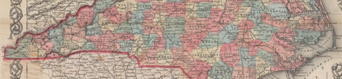
I found it first on this 1870 map of Chatham County, commanding a prominent place along the Deep River next to the now also largely-forgotten town of Haywood. This was mining country then, just to the east of the coal mine in Egypt, N.C.
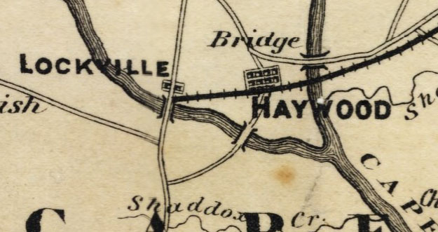
Both Lockville and Haywood faded quickly compared to the fast-rising town of Moncure. By 1933, when this soil survey was published, Lockville had changed its name to Lockport, and Haywood showed very little growth. In the meantime, Moncure, right on the Pittsboro Branch of the Seaboard Air Line Railroad, boasted three churches and a school.
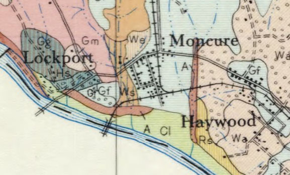
By the 1940s, as this rural route delivery map shows, Lockville/Lockport ceased to appear on maps at all.
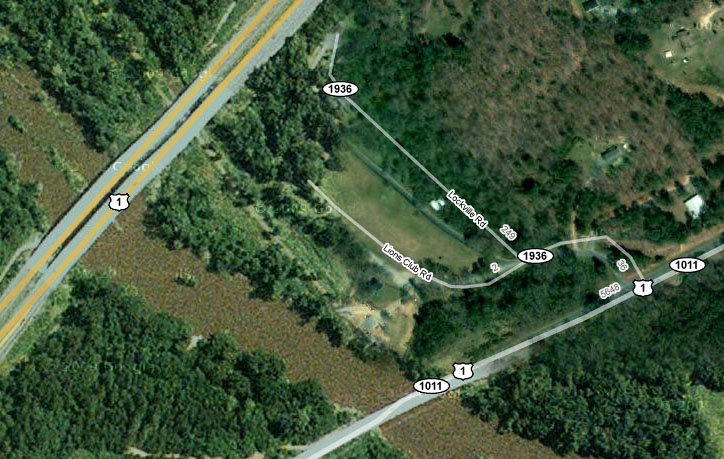
The only remaining evidence of the town — as far as maps are concerned — is Lockville Road, between two highway bridges, just downstream from the locks that gave the community its name. For more about Lockville, see this article, published in the Chatham County Line last September.
There’s also a Lockville St. in Pittsboro, a fragment of a block or two that used to be part of the main southern egress. Nearby is Cornwallis Road, so named because his army camped in that area on their retreat from Guilford Court House. Google maps: http://twurl.cc/1b6v
Sort of a tangential point, but … the N&O article features Patrick Barnes, former Chatham commissioner living near Jordan Lake in the area of Bells. If you go to the 1870 map of Chatham linked in the post, navigate up the Haw from Lockville and then up New Hope Creek, you’ll come to Bell’s X Roads. There the old stage road from New Bern to Salisbury crossed the creek on Cypart’s or Cyprett’s or Sypart’s bridge, now of course under the lake. The original trustees of the University of North Carolina chose this bridge as the point within fifteen miles of which they would site the campus.
Here’s an even more detailed view of the former community of Lockville
from the Chatham County Register of Deeds Office.
There’s a lot more to day about the history of Lockville – see various back issues of the Chatham County Historical Journal.
Here’s that plat:
http://www.flickr.com/photos/29006485@N08/3744591632/
Here are my disjointed notes on Lockville:
A 7/10’s of a mile long falls concludes just below the present Lockville dam; it is most commonly known as Pullen’s Falls (sometimes also called Jones Falls; both are names of former owners of the mill). Much of Pullen’s Falls is covered by the backwater of the Lockville Dam.
In Revolutionary times, Lockville was known as Ramsey’s mill in 1780 for its builder, Ambrose Ramsay or Ramsey, later called Ramsey & Stokes’ mill (Hadley 1970). Ramsey’s grandchildren sold the mill to William Boylan in 1822 (Chatham DB Y, pg 151). John A Williams bought the mill in 1839 (Chatham DB AE, pg 410). Charles J Williams, John A Williams and Jonathan Harelson sold this mill to Richard Smith in 1844 (Chatham DB AF, pg 493) including the dam, mill, ferry boat & landing, and a slave named Jim. During Smith’s ownership, the mill was evidently leased to James Pullen (See Chatham Ct Min Feb 1846). Smith sold the mill to Alston Jones in 1852(Chatham DB AI, pg 11) including the boat, ferry landing, mill building and “a negro man, Jim the miller, aged about 40 years.” Chatham DB AL pg 271 (dated 1851, recorded in 1860) is an easement agreement between Alston Jones and the Navigation Company related to this site.
Before the Cape Fear and Deep River Navigation Company began improvements here, this dam was eight feet high and deepened the river to cover the upper part of Pullen’s Falls. The Navigation Company converted Pullen’s millrace into a canal that carried traffic half a mile below the dam. But Hadley says there were constant problems with the workmanship here and the lock and canal, which had been undertaken in 1852, were not complete until 1859. Consequently no river traffic passed from the Deep into the Cape Fear for the first 10 years of the Navigation Company’s existence.
During the 1870’s George G. Lobdell of the Lobdell Car Wheel Co. purchased an interest in Deep River Manufacturing Co. which then owned the dam at Lockville. Lobdell’s company brought the locks and dam between Endor and Buckhorn on the Cape Fear into working order. For some years, iron ore was mined at Buckhorn, shipped up to the furnace at Endor, and then down to Lockville to be loaded onto the railroad. This operation was purchased by the American Iron and Steel Co. in 1876 and continued for some years.
The dam at Lockville collapsed in May of 1901 (Barringer v. Virginia Trust Co, 132 NC 409, 1903). There was also a suit in 1880 between the owner of the dam and the easement holder (Silas Burns owned the mill at that time I think). In 1920 this site was turned into a hydroelectric plant by the Moncure Manufacturing Company. The hydroelectric plant is still in operation today.
This location is shown as Boylan’s Ferry by Brazier (1833). William Boylan had bought the mill and ferry from the Ramsey family in 1822. As late as 1852 deeds to the Lockville mill property discussed the ferry landing and boat (Chatham DB AI, pg 11).
Thompson (1848) mentions that “Dr. {Robert K} Smith’s bridge” was under construction a mile below the Pullen Dam at the time of his survey. Brien (1852) shows “Pullen’s Bridge” here, so that must have been about the time of the first bridge in the area. Emmons (1856) shows no bridge here on his fold-out map. Instead he shows “Harris Bridge” just below the mouth of Rocky Branch; there is no modern crossing in that location but there are signs of old pilings thee. Ramsey (1870) does show a bridge here. Chance (1885) shows two bridges in this area and a railroad trestle. Presumably the Chance is showing the Harris Bridge and this bridge.
This bridge is shown on the 1876 Lockville plat (Chatham DB 31, pg 83). H A London (1876) mentioned that there was a bridge here in 1876, one of only three on the Deep in Chatham County at that time. In 1877, the County bought this bridge from the American Iron and Steel Co (NCSA).
The Ramsey (1870) map shows no trestle across the Deep River. It must have been built in the early 1870’s, as the 1876 Lockville plat (Chatham DB 31, pg 83) shows the trestle. The original trestle was a covered bridge (Swain 1899).
I was listening to NPR and there was a story about lockville. Most of what was known of Lockville is now at the bottom of Jordan Lake. they talk to one man who owned land and how the govberment was paying 4.50 to the $1 for land in order to make Jordan Lake. Very interesting.