
This Month in North Carolina History
 Just off of Cape Hatteras lies Diamond Shoals, a large area of turbulent waters and constantly shifting underwater sand dunes which can wreak havoc with passing ships. This and other treacherous passages caused so many shipwrecks that wary sailors began to call the waters off of North Carolina’s coast the “Graveyard of the Atlantic.”
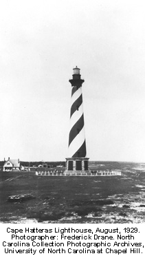
The first lighthouse at Hatteras began operating in 1802 and was effective in helping some boats steer clear of dangerous waters, but sailors complained that it was neither tall enough nor bright enough to provide as much advance warning as they needed. Hatteras was the site of an important naval battle early in the Civil War. The island was occupied in the summer of 1861 by Federal troops, many of whom camped around the lighthouse, finding themselves forced to defend the beacon against a Confederate plan to blow it up. After the war, continued complaints about the effectiveness of the light, combined with natural deterioration of the structure, led the United States Congress to authorize funds for a new lighthouse in 1867. In December 1870, the new lighthouse at Cape Hatteras, destined to become one of North Carolina’s most enduring symbols, was lit for the first time.
The new lighthouse took over two years to build and cost $155,000, more than twice the cost originally allocated by Congress. The familiar black and white stripes were painted in 1873. The finished structure stood 208 feet high, making it the tallest lighthouse in the United States, a distinction that it still holds.
The new light shone for decades, helping ships steer clear of the dangerous passages, but it was these very waters that threatened the existence of the lighthouse. Beach erosion had become so severe that by 1936 waves reached the base of the lighthouse and, without any immediate solutions to stop the encroaching tide, the Lighthouse Service was forced to close the Hatteras lighthouse. For 14 years, it would remain dark.
In 1950 the lighthouse was restored, a new electric light was installed, and the Hatteras lighthouse began its second life. The next half-century saw a number of efforts to reinforce the shoreline – sand was pumped in to extend the beach, concrete bunkers were poured, and a large seawall was built around the base of the lighthouse – but none were able to keep the ocean away for long. Finally, in 1999, the entire lighthouse was lifted from its foundation and moved to a new location 1,600 feet from the sea. In the years since the move, the lighthouse has reopened to visitors, has withstood several severe storms and, most importantly, has continued to shine, warning passing ships that they were approaching the “Graveyard of the Atlantic.”

Suggestions for Further Reading
Carr, Dawson. The Cape Hatteras Lighthouse: Sentinel of the Shoals. Chapel Hill: University of North Carolina Press, 2000.
Duffus, Kevin P. The Lost Light: The Mystery of the Missing Cape Hatteras Fresnel Lens. Raleigh: Looking Glass Productions, 2003.
Stick, David. North Carolina Lighthouses. Raleigh: North Carolina Office of Archives and History, 1999.
Cape Hatteras National Seashore, National Park Service
Image Source
“Fifth L.H. District.” Map published in Annual Report of the Light-House Board to the Secretary of the Treasury for the Fiscal Year Ended June 30, 1897. Washington, D.C.: Government Printing Office, 1897. Detail.