I thought I knew something about North Carolina history and geography, and felt pretty confident that I’d already spotted many of the oddities and mysteries lurking in old maps, but then somebody pointed out the Big Desert in Robeson County. It shows up on Samuel Pearce’s 1872 map of the state:
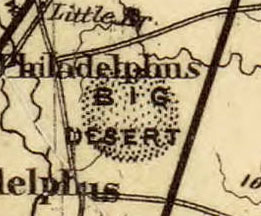
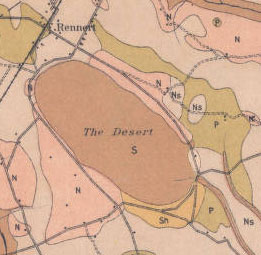
I know that sandy soil is common in eastern North Carolina, but the existence of an actual desert was news to me. I decided to look at later maps, to see if this was just a mistake or misunderstanding on the Pearce map, but sure enough, the desert showed up on one after the other. It was there on a 1884 map of the county, and then again on a 1908 soil survey, labeled simply as “The Desert”:
Soil survey maps are usually very reliable, so I decided to look at a recent satellite image to see if I could find anything roughly that shape near the town of Rennert. Here’s what I turned up using Google Maps:
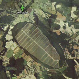
The shape of that area looks exactly the same as that shown on the 1908 map. But the question remains, what in the world is it? Are there, among the many readers of this blog, any Robeson County residents who can tell us what exactly somebody would find if they went to the “Big Desert” today?
Here’s what William S. Powell says in the N.C. Gazetteer (p. 141):
The Desert, a pocosin in n Robeson County between Big Raft Swamp and Big Marsh Swamp. Oval shaped and presumed to be one of the Carolina Bays, which see. Covers 1,200 acres; water depth varies from 6 inches to 4 feet, but one spot is said to be bottomless. Game abounds here, especially deer.
And (p. 89):
Carolina Bays, oval-shaped lakes, swamps, pocosins, savannahs, and peat beds in se North Carolina, e South Carolina and ne Georgia. Several explanations have been advanced as to the origin of the Carolina Bays, but the most generally accepted one is that they were formed thousands of years ago by a shower of meteorites. White Lake, Jones Lake, Singletary Lake, and Lake Waccamaw are Carolina Bays. There also are numerous others, many of which no longer contain water.
A comment in honor of Endangered Species Day: I’d be willing to bet that this “desert” was (or still is?) a home for the Venus flytrap, as I wrote about recently on the Hugh Morton blog. This is the area where Josephine Humphrey’s book “Nowhere Else on Earth” is set.
Linda McRae, Town Clerk of Rennert, got the following explanation:
It’s located off Rennert Road near Mary C Road. Mr. Emmett McRae the former Mayor of Rennert said it was a wood dessert not sand and now the trees has been cleared and it is mostly farm land.
The town of Rennert has a facebook page now. It can be found at:
It wouldn’t be related to the nonexistent Arenosa Desert, put on N.C. maps starting in the 1670s, would it?
http://dc.lib.unc.edu/cdm/singleitem/collection/ncmaps/id/114/rec/13
The Great Desert is not named for the Carolina Bay, the Carolina Bay is named after the big pile of sand. The sand has multiple origins. The largest area of sand or the Great Desert is on the south and east sides of the bay. The primary source of sands is marine sands of Pliocene age from shallow near shore flats, another is bay rim sands and what may be the biggest source of sand is deflation dunes from wind erosion of the proximal Raft Swamps east valley wall. Mobilized sand from wind erosion augmented the bay rim sands creating the Great Desert. A considerable area of the sands have been used as borrow or have been dug up and trucked away but there’s still a tremendous amount of sand left.
Thanks for this dialogue! I have been torn between “Ten Mile Swamp” and “Great Desert Bay” for the Carolina bay outside of Rennert. The USGS has identified the entire drainage system from inside the bay and for the next ten miles as “Ten Mile Swamp”, and that name appears on Google Earth’s main artificial drainage channel down the length of the bay. The USGS also declares the basin itself as “Great Desert” in their Geological Names database. I’m going with “Great Desert bay” – lower case on “bay” – to reference the landform.
Mom grew up in Robeson county. She talked about the desert and fires in Summer. Now we figure peat bogs fires are hard to extinguish underground. But she new something we never heard of. The Desert in Rennert.