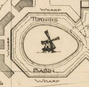
 Some of my favorite maps in the North Carolina Maps project are maps of towns and communities that never existed. One of the most detailed by far is a map of New Holland, in Hyde County. Planned for the southern shore of Lake Mattamuskeet, New Holland was planned around 1910 by a company that wanted to drain the lake for farm land. The elaborate map shows a decidedly Dutch theme to the town, with canals, wide avenues named Amsterdam and Haarlem, and even a windmill. Unfortunately, the town was never completed. The developers gave up in 1934 and the lake was refilled.
Skip to content
Exploring the History, Literature, and Culture of the Tar Heel State