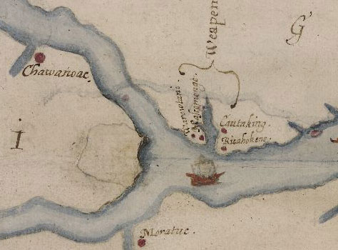
Researchers from the U.S. and U.K. announced earlier today that a 16th century map of coastal Virginia and North Carolina reveals the location of a planned fort or settlement. And, they suggest, that spot, at the confluence of the Roanoke and Chowan rivers, may be where settlers from the Lost Colony headed.
The lozenge shape on John White’s “Virgenia Pars”, which researchers suggest represents a fort, was discovered when experts at the British Museum used lights and other techniques to study details hidden by a patch on the map.

A panel of historians and archaeologists assembled by the First Colony Foundation discussed their findings and theories this morning at Wilson Library in Chapel Hill. Panelist James Horn, an historian and author of A Kingdom Strange: The Brief and Tragic History of the Lost Colony of Roanoke, says that before John White left his fellow colonists in 1587, the settlers had already discussed moving about 50 miles inland. That distance roughly compares to the location of the fort depicted on the map. Additional details of the First Colony Foundation’s research and theories are here.
White’s “Virgenia Pars” map is considered relatively accurate in its depiction of the region’s geography. And The News and Observer reports that the site of the planned fort or settlement is “near Scotch Hall Preserve, a golf course and residential community just across the Albemarle Sound from Edenton.”
Although archaeologists expect to study the area of the planned fort or settlement, a timeline for such work has yet to be disclosed.
