December 1804: The Walton War

This Month in North Carolina History

Approximate location of the disputed land in the Walton War.

Arguments between states in this country are usually settled more or less decorously and peacefully through debate and compromise. In at least one instance, however, such a quarrel resulted in armed conflict and loss of life. In December 1804, in disputed land along their common border, several Georgians assaulted and killed a Buncombe County, North Carolina constable, and North Carolina responded by sending in a detachment of militia to restore order and assert its authority in the area. Called the Walton War, this incident was part of a series of more peaceful boundary conflicts between North Carolina and its neighbors which were caused by confusion inherited from British colonial rule and territorial pressure resulting from the creation of the new American nation.

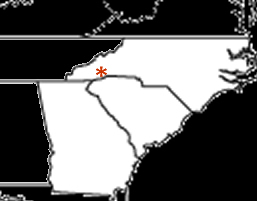
At the time of the American Revolution, North Carolina’s boundary with South Carolina was in dispute, particularly in the western part of the state. After the Revolution the new government of the United States pressed states that had claims on land between the Appalachian Mountains and the Mississippi River to cede those lands to the national government. North Carolina gave up its claim to a broad swath of land from which most of the state of Tennessee was later formed. South Carolina, however, had only a narrow strip to cede between the southern border of North Carolina and the northern border of Georgia. In 1802, after long negotiation with the federal government, Georgia surrendered claim to the territory from which Alabama and Mississippi were formed. As part of the negotiation, the federal government gave Georgia the strip recently ceded by South Carolina, giving Georgia and North Carolina a common border. Unfortunately, this common border had never been accurately surveyed, and there was substantial debate about how it should be defined. The eastern edge of this strip, as Georgia defined it, contained land at the head of the French Broad River that North Carolina believed to be part of Buncombe County which at that time was the only county in the far western end of the state.

This messy situation was aggravated by the presence of settlers in the disputed territory who began coming over the Blue Ridge about 1785. By 1802 there were some 800 people in the area. The fundamental problem was that many of the settlers held their land by grant from South Carolina while many others had North Carolina grants. In the confusion over state authority settlers saw the possibility of losing their land and hence their livelihood. In 1803, to solidify its claim, Georgia organized the disputed territory into Walton County, named for George Walton, a signer of the Declaration of Independence. Relations between residents in the new county rapidly deteriorated. Holders of South Carolina land grants supported the new county government and resisted the authority of Buncombe County officials. North Carolina grant holders supported Buncombe and refused to acknowledge the Walton County government.

The crisis came in December 1804 when Walton County officials and their supporters attempted to intimidate and possibly dispossess several outspoken partisans of Buncombe. One of these, John Havner, a Buncombe County constable, was struck on the head with the butt of a musket and killed. In response, Buncombe County called out the militia. A detachment of seventy-two men, under Major James Brittain, marched into Walton County on December 19, 1804, where they were joined by twenty-four North Carolinians living in the disputed area. Ten important Walton County officials were taken prisoner and sent to Morganton, North Carolina, to be tried in the death of Havner. The Walton County government was effectively crushed. North Carolina and Georgia continued to quarrel over the disputed territory until 1807 when commissioners from both states met to establish the boundary. Joseph Caldwell, president of the University of North Carolina, and Joseph Meigs, president of the University of Georgia, were charged with making the scientific observations for the party and after several trials established that the true boundary was a number of miles south of its assumed position. The commissioners from Georgia admitted that all of Walton County was in fact in North Carolina.

In the end North Carolina recognized the South Carolina land grants and extended amnesty to those who had opposed the state in the Walton War — except for the ten men accused of the death of John Havner. They, however, had escaped from the jail in Morganton and fled the state, never to be seen again. Although Havner was the only fatality, stories of the Walton War grew over the years creating a legend of the conflict in which truth and fiction freely mixed. In the legend, dozens of Georgians died in pitched battles with North Carolina militia. The frustrated farmers of Walton County, worried about the legality of their land grants, became, in some stories, bands of vicious desperados inhabiting a “no man’s land” beyond the law.

By the late twentieth century the Walton War was almost, but not quite, forgotten. In 1971 Georgia questioned the location of its boundary with North Carolina, and the North Carolina General Assembly, reported by the press to be in a “jocular mood,” passed a resolution urging that the National Guard be called out to defend the border.


Sources
Carpenter, Cal. The Walton War and tales of the Great Smoky Mountains. Lakemont, GA: Copple House Books, 1979.

Reidinger, Martin. “The Walton War and the Georgia-North Carolina Boundary Dispute.” Typescript in North Carolina Collection, University of North Carolina at Chapel Hill, 1981.

Skaggs, Marvin Lucian. “North Carolina Boundary Disputes Involving Her Southern Line.” James Sprunt Studies in History and Political Science, Vol. 25, No. 1. University of North Carolina Press, 1941.

Durham Morning Herald, 12 September 1971 as found in North Carolina Collection Clipping File through 1975, Subject Clippings, vol. 177.

Encyclopedia of North Carolina

Illustration from 1924 biology textbook

Even before William S. Powell wrapped up work on the Dictionary of North Carolina Biography we knew that he was planning an encyclopedia. We looked forward to it more than most, knowing that it would be a reference tool that we would use almost every day in the North Carolina Collection. We were right. Decades in the making (Powell says in the introduction that he first had the idea for the book shortly after the end of World War II), the Encyclopedia of North Carolina is finally here.

The Encyclopedia has everything that we knew it would — succinct, authoritative articles about historic places and events — but it also has so much more, covering North Carolina culture in all of its rich variety. There are entries for “Headache Powders,” “Revivals,” “Hoi Toiders,” “Grits,” and even an entry for “Mooning,” written by William S. Powell himself. Combined with the North Carolina Gazetteer and the Dictionary of North Carolina Biography, both of which were also edited by Powell, North Carolina now has a reference shelf that puts a wealth of information at our fingertips.

Thanksgiving 1905

“It oft behooves a State, as well as an individual, to look at the past, that it may realize the mercies for which it has to be thankful, and to give expression to its gratitude by words and acts of praise.”

Thus begins Governor R.B. Glenn’s 1905 Thanksgiving Proclamation. It’s a rather long document, listing many things from the previous year for which North Carolinians should be thankful, including, “we have been blessed with fair crops, and prices for farm products have been above average,” “the settlement of our outstanding debt upon a just and honorable basis,” “no scourge of disease or pestilence has to any great extent visited our State,” and “temperance and sobriety in all things are being practiced by our citizens.”

In his closing, Governor Glenn asks that North Carolinians take Thanksgiving Day to gather, pray, rejoice, and, above all, “while enjoying this holiday, that they do nothing unworthy of the reputation of the State.”

Preachers and Monkeys

Illustration from 1924 biology textbook

The North Carolina Collection is excited to announce the launch of a new online exhibit: The Evolution Controversy in North Carolina in the 1920s. This website enables users to read original documents and newspaper articles related to the heated debate over the 1925 “Poole bill,” a resolution condemning the teaching of “Darwinism” in the public schools and universities in our state.

Memorizing Maps

At the “Maps for the New Nation” conference in Chapel Hill last weekend, Jeff Patton from the Department of Geography at UNC-Greensboro gave a great talk on 19th-century school atlases. Dr. Patton showed a couple of examples from a “poetical geography,” in which geographic names were set to rhyme to facilitate memorization by students. I went looking for one of these in the North Carolina Collection and found Needham Bryan Cobb’s Poetical Geography of North Carolina, published in 1887.

If schoolchildren of the 1880s had to memorize all of the place names in this volume, they had quick a task ahead of them. Cobb sets the counties, rivers, creeks, sounds, bays, and mountains to rhyme, several hundred names in all. Here’s an example:

SOUNDS OF N. C.

Just eleven shallow sounds
Slumber on our shore: —
Albemarle and Pamlico,
Topsail, Stump, and Core,
Currituck and Croatan,
Where the wild geese soar,
Wrightsville, Masonboro’, Bogue,
Roanoke – and no more.

If you find that too easy and are ready to set more to memory, the whole book has been digitized and is part of East Carolina’s Eastern North Carolina Digital Library.

November 1765: The Stamp Act Crisis in North Carolina

This Month in North Carolina History

On Saturday, November 16th, 1765, Dr. William Houston, a respected resident of Duplin County, arrived in Wilmington, North Carolina for a short visit. Houston had recently been appointed – to his great surprise, since he had not sought the position – distributor of stamps for the colony of North Carolina under a new revenue law enacted by the Parliament of Great Britain. Houston may have heard that the new tax was unpopular among his fellow colonists, but he quickly learned that the citizens of Wilmington were particularly upset about it. A crowd of three or four hundred people accompanied by drums and flags appeared at his inn and escorted Houston to the courthouse where, in the presence of Wilmington’s mayor and several aldermen, he was told that he would have to resign his position as stamp distributor. Under the circumstances, and not having wanted the job in the first place, Dr. Houston resigned on the spot. This made him the crowd’s hero, and Houston was carried in an armchair back to his inn and toasted by his admirers with “the best Liquors to be had.” More toasting followed around a bonfire that night as opponents of the new tax cheered themselves and their noble endeavor. The assault on Dr. Houston, while no one was harmed and the whole affair was more or less good-natured, was a symptom of a very real and serious division between Great Britain and her American colonies, a division which would soon lead to revolution.

For much of their early history the British colonies in North America had been treated with what has been called benign neglect. Great Britain regulated the colonies’ external trade through a series of navigation acts, but colonial assemblies took over responsibility for their internal affairs, including levying taxes and appropriating money. This changed as a result of the Seven Years War (1756-1763), which Americans knew as the French and Indian War. In North America British and colonial troops fought the French based in Canada, but Great Britain was also engaged in Europe and India in what Winston Churchill called “the first world war.”

Britain made many important gains during the war but at a great cost, and emerged from the conflict determined to bring its colonies under firmer control and raise some of the revenue necessary to support the new empire from colonial sources. As a part of this new policy Britain decided to station a permanent army in America to provide for colonial defense and pay for that army with funds raised in the colonies themselves. To this end Parliament, in March 1765, required that Americans pay a small tax on certain kinds of public papers, such as newspapers, pamphlets, insurance policies, ship’s papers, playing cards, and legal papers. To show that the tax had been paid, a stamp would be affixed to the paper. To the British this seemed reasonable and fair. To many American colonists, however, it violated the custom that direct taxes be levied only by colonial assemblies and the principle that Englishmen could only be taxed by a body in which they were represented. First resistance to the Stamp Act came in Boston, where the property of the stamp distributor was burned and the home of the colonial governor attacked. In response to an invitation from the legislature of Massachusetts, nine colonies sent delegates to the Stamp Act Congress in October 1765.

No delegates from North Carolina attended the Congress, but feeling in the colony, especially in the coastal area, was very much opposed to the tax. Governor William Tryon worked hard to convince North Carolinians to accept the tax, but when HMS Diligence arrived on November 28th bringing the tax stamps, the colonists refused to let them be brought ashore. In mid-January two ships were seized by the British navy in the Cape Fear River for sailing with unstamped papers. A thousand armed colonists forced the release of the ships and their crews. Governor Tryon discovered that he could not rely on magistrates and other law enforcement officials to suppress the disorder since so many of them had joined the protesters. The tension was finally eased by the repeal of the Stamp Act in March 1766. Life in colonial North Carolina returned to normal, but the Stamp Act Crisis had revealed serious, on-going problems in the relationship between Great Britain and the American colonies.


Sources
Lawrence Lee. “Days of Defiance: Resistance to the Stamp Act in the Lower Cape Fear,” North Carolina Historical Review, vol. 43:2 (Spring 1966).

Donna J. Spindel. “Law and Disorder: The North Carolina Stamp Act Crisis,” North Carolina Historical Review, vol. 57:1 (Winter 1980).

UNC in NYC

Program from UNC - Notre Dame game, 1949

While we all know about Sherman’s march through the Carolinas, we were not as familiar with North Carolina’s November 12, 1949 invasion of New York City. On that day, slightly over 37,000 zealous Tar Heels descended on New York for the football game between UNC and Notre Dame in the unlikely setting of Yankee Stadium. It appears that the Tar Heel incursion into the Big Apple caused quite a stir. According to the New York Times account, the pre-game festivities of “the Southern forces [have] turned the midtown into a neon-lighted campus.” The spirited UNC fans also “staged a rally that was enthusiastic even by Times Square standards.”

Entering the game undefeated and as the nation’s top-ranked team, Notre Dame proved to be too powerful for the underdog Tar Heels. While the Daily Tar Heel reported that North Carolina “played with utter contempt for the greatness that is Notre Dame,” the Heels ultimately lost to the Irish by a score of 42-6. The DTH went on to report that the exuberant North Carolina fans’ “traditional end-of-game singing of ‘Hark the Sound’ came out with such gusto that several thousand of the rabid New York fans stopped dead in their usually hurried tracks” to listen.

Lost Colony Still Lost

Today’s News & Observer has a story about the continued search for archaeological evidence of the “lost colony” on Roanoke Island. To aid their efforts, I thought I’d present a map showing exactly what the island looked like when the British colonists landed in 1585:

Roanoke Island

Okay, so maybe it’s not going to be the key to finding evidence of the disappearing colonists after all, but it is a nice image. This illustration is a detail from a map in the 1590 edition of Thomas Hariot’s Briefe and True Account of the New Found Land of Virginia. The North Carolina Collection is in the process of digitizing the images from a rare, hand-colored copy of the book. Check back in a couple of months to see a fascinating collection of the earliest published images of North Carolina and of Native Americans on the North American coast.

Topographic Map Database

From the Joyner Library at East Carolina University comes a very useful tool for finding and using topographic maps – the TopoNC Map Database. TopoNC allows keyword searching for places (including crossroads, subdivisions, towns and cities) and features (such as rivers, swamps, mountains, bays, and forests). Click on the link for more information and to begin searching the database!