Rock Branch, North Carolina

Rock Branch (Harnett County) was home to a health resort named Eden Colony, which was developed by W.W. Giles. John Hairr provides a brief history of Eden Colony in his book Harnett County, A History. In 1906, Giles bought 1,200 acres of land, divided it into 60 plots on both sides of the railroad tracks for dwellings, and left a large open section of land for daily exercise.

According to Hairr, the early success of the resort community was based on dewberry farming and heavy advertising. The postcard of Eden Colony above shows two views of the town, including a cottage and a view of the town, including the railroad tracks, the post office, and some green space. Giles would advertise the community with pamphlets, booklets, postcards, all in addition to the big sign that was visible from Rock Branch’s train depot.

Just before World War I, the demand for dewberries dropped significantly – in 1913, the town was renamed to Olivia, in honor of W.J. Olive, who introduced flue-cured tobacco to the area in 1912.

There are several other postcards showing dewberry farms in the Sandhills region in our online collection. You can view them here.

Two New Georeferenced Maps Online

There are two fun, new georeferenced maps on the NC Maps site that we wanted to share.

The first is a map of the Battle of Bentonville from the Official Atlas of the Civil War.  The map is accurate enough, and the satellite image good enough, to be able to see how the landscape shaped the battle.

The other one is a map of the golf course and racetrack at Pinehurst Country Club in 1922.  Many of the holes line up pretty well, showing where things have changed, and where they haven’t.

We’ve got a postcard of a country club in Pinehurst, dating to ca. 1915-1930.  It’s unclear whether this image is the same country club in the map above, but the footprint of the clubhouse on the map looks like it could possibly be the same one in the postcard below.

North Carolina State Historic Boat – the Shad Boat

The shad boat was originally designed in the 1870s by George Washington Creef, who can be seen standing next to the shad boats in the postcard above.  According to Lawrence E. Babits’ entry on shad boats in the Encyclopedia of North Carolina, Creef “combined traditional split-log techniques with conventional plank-on-frame construction” to produce a safe, shallow boat in the period after the Civil War when timber was scarce.

Local and durable timber was typically used in the construction of shad boats, including cypress, cedar, and juniper.  Shad boats were produced along the Outer Banks from Elizabeth City to Ocracoke Island because Creef taught others in the area how to construct the boats, which were named for the fish they were used to catch (shad!).  The long boats were ideal for the sound waters because they were stable and easy to maneuver in waters that were shallow and susceptible to sudden changes in weather.  Production of shad boats slowed considerably in the 1920s and 1930s because they were expensive to make. In 1987, the shad boat became the North Carolina State Historic Boat.

The NCC has other materials related to shad fishing, including this Map of Tar River, N.C.: showing approximate location of seines fished for shad in 1906, which shows bridges, seines, landings, fisheries, creeks, and mills along river.  The photograph below (P1-28-M29-F53) of fisherman at Manteo was taken by W.H. Zoeller in ca. 1900, and provides a better view of a shad boat.

Playmakers Theatre – A Capital Idea

Playmakers Theatre, formerly Smith Hall, has rather interesting capitals that top its four columns. Rather than sticking to the leaves seen in traditional Corinthian columns, the building features architect A.J. Davis’ unique design that used ears of corn and stalks of wheat.

You can read more about Smith Hall in DocSouth’s Buildings of the First Century of the First State University digital collection.

A Monazite Mine in Shelby, NC

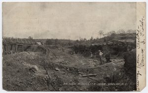
Above is an image of a Monazite mine in Shelby, NC, dating to ca. 1906. Monazite was used in the gas mantles of the late 19th century and early 20th century that provided incandescent light.

According to an article in a 1907 bulletin published by the US Geological Survey, monazite mines in North and South Carolina produced 846,175 pounds of monazite sand in 1906, the year this postcard is postmarked. At that time, the monazite mined in the Carolinas was valued at approximately 18 cents per pound.

Monazite was mined in the US only for a short time before larger deposits were found in India and Brazil. In addition to the other sources pertaining to monazite held by the NCC, you can also check out the Wikipedia article on the mineral here. We’ve added a thumbnail image of the postcard above to the article.

Creek Lights and Lightships

In addition to the traditional lighthouses along the North Carolina coast, here are two alternative examples used to keep ships and sailors safe during their night travels:

Above is a postcard from ca. 1905-1915 showing children playing on a creek lighthouse located in Southport, Brunswick County.  This lighthouse was likely built in 1849.

Below is a postcard of the Diamond Lightship stationed off the coast of Morehead City, NC, where it would stay moored in place and make use of its large warning lights.  This card dates to ca. 1948.

Hillsborough Town Clock

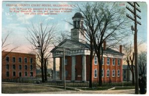
The postcard above shows the Orange County Courthouse and dates to ca. 1905-1915. The clock in the clocktower is said to have been a gift to the town by King George III in 1789, however, the history of the clock remains somewhat murky.  According to two histories of the town of Hillsborough (Nash’s Hillsboro, Colonial and Revolutionary and Lloyd’s History of the Town of Hillsboro), the clock was made in Birmingham, England around 1760 as a facsimile of the clock in the Independence Hall in Philadelphia.  Both clocks were said to have come to the country around the same time, ca. 1766.  It’s unclear whether or not the clock was really a gift from King George III or brought to the town by one or more of the prominent local politicians, such as David Fanning, the register of Deeds, Governor Tryon, or the Earl of Hillsboro.

The clock was relocated several times and involved in numerous disturbances, including a raid on the town, a swim in the Eno River, the Regulator’s War, and then the Revolutionary War.  It wasn’t until 1846 or 1847 that the clockwas placed in the Orange County Courthouse, where it still resides today.