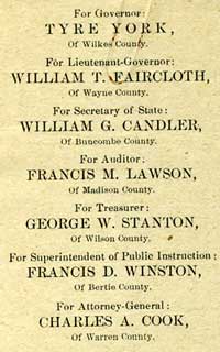
 Throughout this election season, I’ve been sharing some of the North Carolina Collection’s wonderful collection of political ephemera (I hope you’ve enjoyed). I’m sharing another piece today; the image to the right is a list of Republican Party candidates for state office in 1884.
However, I’d also like to turn this posting into a solicitation for more ephemera. Yesterday, our collection development librarian (the person in charge of getting “stuff” for the NCC), sent out an email to North Carolina librarians. In this email, she asked them to save all of the various politically related mailings that they have been getting, pack them up, and mail them to us. Well, I want to do the same thing with our loyal NCM readers. Since all of the NC Collection’s staff members live near Chapel Hill, most of the political ephemera we collect is “Triangle-centric.” Our collection, however, seeks to document the history and culture of the entire state. So, for those of you in the western or eastern (or other parts of the Piedmont) parts of the state, please do the following: 1) save the mailings you get 2)pack them up 3)send them to the NC Collection. Who knows…a hundred years from now my replacement may be blogging about the ephemera you sent to us in 2008.


